
 Your Account
 Email Sign-Up
 Buy Annual Pass

Understanding the occurrence of severe storms in Southeast Michigan
June 5, 2024
Ali Groulx, Park Interpreter
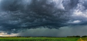
Hot and humid air masses travelling north from the Gulf of Mexico will one day meet their antithesis: extreme cold air travelling south from Canada. The traditional meeting place of these masses, often called tornado alley, is expected to continue expanding northeast, upping the odds for a severe weather event. Thunderstorms hitting Southeast Michigan in recent years have held elevated amounts of humidity, made possible by an unusually warm atmosphere, which ups the ante when it comes to fueling severe storms. Climate change caused by human activity has greatly increased the rate of storm systems with the potential to twist themselves into oblivion, wreaking havoc and impacting lives. That does not change the fact that historically, severe weather can and has happened in our area.
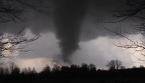
The year was 1976 – it was 70°F and sunny, a perfect first day of spring in West Bloomfield. Residents soaked in the unusually warm March afternoon, preparing for the nearly 50°-degree drop coming the next day. It fell silent that evening as light penetrated the clouds, the wavelengths bouncing off ice crystals to reflect a sickly green back down to Earth. Time seemed to stop, until it began to thunder and rain – downpouring with such a fierceness that erased familiar structures from sight, even a few yards away. The frigid cold front mingled with warm, humid air, creating the perfect conditions for one of Earth’s most violent storms, a tornado.
The air inside the impeding cumulonimbus cloud spent the morning forcefully rising and was now quickly transforming into the equivalent of a videogame boss level – a supercell. Four other tornados touched down in Southeast Michigan that day, though the tornado that ripped through from Halstead Road to Middlebelt reached winds of up to 260mph. People tried to describe the sound: a crashing jet, a freight train, a bombardment. The residents of the town were left with destruction in the aftermath, and just as quickly as the storm came, it went. The 1976 tornado was rated an F4 – the last one of its strength to hit Southern Michigan. The shock of the powerful tornado resonated throughout the state, covered by newspapers and broadcasts alike.

The destructiveness of volatile storms has become increasingly more visible in the digital age, and due to climate change, more areas are beginning to experience a higher rate of thunderstorms that contain the right ingredients to whip themselves into a more serious weather event. In late August of 2022, an incoming cold front brought forth a line of storms that raced over the Mitten. These storms intensified dramatically when they were faced with the muggy, unstable atmosphere hanging over Southeast Michigan, causing an interaction known as a gustnado. These are surface level disturbances act like mini tornados; unlike tornados, they are not connected to the ‘Mother Cumulonimbus’ up in the sky. Gusts of 60 to 75mph caused a great amount of damage to powerlines and properties that day. With any major damage, it takes time to access the situation and begin clean-up efforts.
The winds during the late August storm of 2022 reminded us of the power that a severe thunderstorm can possess, creating several weeks of work for our Natural Resource crew to clean up fallen trees and limbs on trails and recreation areas. The Metroparks Natural Resource department inspects high traffic areas year-round for trees that are diseased or dying, trimming or removing them as necessary. High-risk trees are not the only ones who can suffer damage in a severe storm; healthy trees can be at-risk, too. We become attached to the landscapes that surround us, and when one is damaged by weather events out of our control, it can be unsettling. There is light at the end, so to speak; the openings made by downed trees have the potential to encourage trees like oaks to regenerate, and breaks in the tree canopy can let in rays of sunlight for forest-dwelling animals- everything from snakes to butterflies- for basking.
Our landscape changes after severe weather events, sometimes dramatically. After seven tornados touched down in August of 2023, there are still stretches of I-96 that are visibly windswept. The F2 tornado that recently tore through Portage and Texas Township was harrowing, especially for the healthy, mature trees in the area, captured on video unceremoniously laying down their trunks. Storm impacted communities will recover in time, but the scars and stories of the violent uncertainty and destruction will remain. Every year there is a state-wide tornado drill on March 20th, marking the anniversary of the 1976 F4 tornado in West Bloomfield. The resilience and fellowship demonstrated almost 50 years ago shows us that the sense of community in Southeast Michigan outstrips the strength of devastating storms. As perilous winds, thunderstorms, tornados, gustnados, snow squalls, and polar vortexes continue to find their fuel above our two Peninsulas, we can learn to be prepared. Pay attention to your local weather forecasts and take stock of your environment for any adjustments you can make to reduce storm impact on your lives. In the meantime, you can help gather data on weather conditions and precipitation for climate scientists through the Community Collaborative Rain, Hail, and Snow Network (CoCoRaHS).
Learn more about what you can do to prepare yourself and your loved ones for extreme weather events through the following links:
MiReady: Thunderstorms and Lightning
MiReady: Flooding and Landslides
Another way of taking action and helping to protect your community, is to become a trained volunteer Weather Spotter by taking a Sky Warn class. These volunteers provide the National Oceanic and Atmospheric Administration’s (NOAA) National Weather Service with ground truthing of observable weather events.
Learn more about the Michigan Sky Warn program and take a class to become certified here: Miskywarn.org
 YOUR ACCOUNT